 Jake Graham
Hidden deep in the Rockies and only visible by boat, Spirit Island is one of Canada's most iconic places – and a sacred site for those who have sealed it off from the world.
On my seventh day in the Canadian Rockies, all the mountains disappeared. The previous afternoon, I had paddled for hours through Maligne Lake's turquoise-coloured waters, past glaciers spilling off the serrated teeth of the Queen Elizabeth Range and towards the towering pinnacles of an alpine cathedral known as the "Hall of the Gods". But when I woke up and unzipped the flap of my tent, everything was gone, blanketed in a wall of fog so dense it felt like a dream.
After wiping my eyes in disbelief and stuffing my gear back into the hatches of my kayak, I set out blindly into the void. The world soon melded into an ethereal haze beyond the bow of my boat. There was no clear sense of earth and sky, water and land or where I was.
Somewhere to my left, the heavy strides of a bull elk suggested I was being watched. High above, a 7,000-year-old glacier creaked and groaned as its meltwater tumbled into the lake. Up ahead, the murky silhouettes of evergreen trees appeared and vanished in the vapour like ghosts.
 Eliot Stein
Still, I knew that if I kept paddling and peering through the mist, I'd eventually see it: Spirit Island, the world's most famous isle you can't visit.
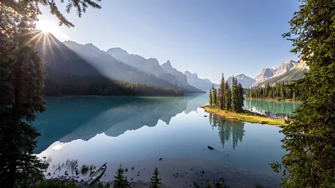
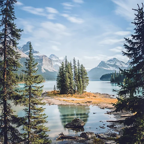
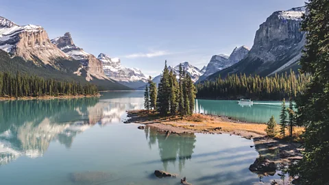
Often called the "jewel" of Jasper National Park, Spirit Island is a tiny, uninhabited strip of land with a near-mythical allure. For much of the year, the island isn't actually an island, but a peninsula connected by a narrow isthmus to Maligne Lake's eastern shore. But despite being located 14km from the nearest road or hiking trail, and 49km from the closest town, this far-flung landmark has become one of the most iconic sites in Canada.
The island's striking position set against a ring of snowcapped peaks first captured global attention in 1960, when Kodak displayed a 18m-wide image of it inside New York City's Grand Central Station. In the decades since, Apple has used a photo of the island to showcase the camera quality of its new iPads, it's appeared in American films and TV shows and been plastered on roadside billboards across Canada. Today, tens of thousands of travellers every year head out on Maligne Lake to photograph the island's pine trees stretching skyward towards the Hall of the Gods.
"When you see a picture of Spirit Island, it's hard to understand that places like this exist in real life," said Tyler Riopel, the CEO of Tourism Jasper. "It's one of the most awe-inspiring places in the world."
Riopel explained that since private, gas-powered boats are prohibited in the national park, there are only two ways to see the island: by boarding a public cruise, which stops at a nearby viewpoint for a 15-minute photo-op, or by embarking on a 28km round-trip canoe or kayak journey from the lake's northern tip. "The [cruise] is a great way to see it in a shorter period, but paddling it is an unreal experience," Riopel said. "The whole majesty of it is best seen from that perspective."

 Jake Graham
That's because even though Spirit Island is small enough to cross in just a few steps, the only people legally allowed to step foot on it are members of the Stoney First Nation, who consider the island sacred.
"Since time immemorial, these mountains have been our home," said Barry Wesley, a Stoney knowledge keeper and language protector. "For thousands of years, we would go to Spirit Island to conduct healing ceremonies, but when Jasper [park] was created back in 1907, we were forced out. The Creator gave us a responsibility to look after this land and this island, and now we are finally reconnecting with it again."
While its official name is Spirit Island, Wesley explained that it has always been Githni-mi-Makoche ("Healing Island") to the Stoney, a place possessing immense curative powers thanks to its unique position bridging land and water and ringed by mountains on three sides. The Stoney believe these mountains represent their ancestors, and after sensing something deep from his family's past, Wesley set out to regain the Stoneys' access to the island and reclaim this small piece of the park.
Spirit Island is symbolic of a larger trend echoing across the Canadian Rockies, as Indigenous peoples are increasingly reclaiming access to ancestral lands once lost to national park creation. Nowhere is that more poignant than in Jasper, where a series of devastating wildfires have ripped through Canada's largest national park in the past decade, ravaging the land and calling the Stoney home to perform their first healing ceremonies on Spirit Island in more than a century.
 Jake Graham
Now, as much of Jasper recovers and parts of the Rockies grapple with climate change and overtourism, the Stoney hope that their sacred island can serve as an example of Indigenous-led land stewardship. And as I paddled through the mist, Wesley's parting message felt like a prophecy.
"When you go towards Spirit Island, you will feel its energy," he told me. "Take your time, listen and it will tell you a story. And by leaving no footprint, you will help it maintain that same energy so others can feel it too."
"The finest view any of us had ever beheld"
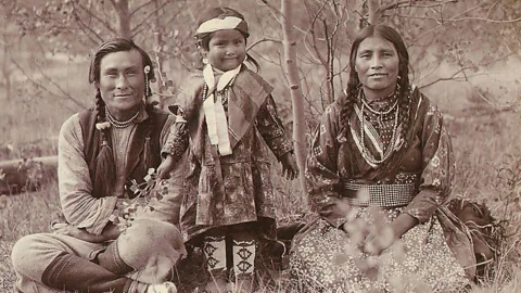
In 1907, a 46-year-old painter and photographer from Pennsylvania named Mary Schäffer Warren was chasing a rumour that had been circulating for years – that somewhere, deep in the mountainous folds of the Canadian Rockies, there was a "glowing" lake known only to the area's Indigenous residents. After searching for weeks, she failed to find it, but a Stoney hunter named Samson Beaver provided her with a hand-drawn map revealing the lake's location.
The following summer, the American returned, clutching Beaver's map and accompanied by three white guides and 22 horses. During the eight weeks, the party endured frigid nights, mosquito swarms and treacherous river crossings. But after climbing to the top of a mountain and gazing down, they finally spotted it, with Schäffer Warren writing: "There burst upon us… the finest view any of us had ever beheld in the Rockies."
 Getty Images
Schäffer Warren's 1911 book Old Indian Trails of the Canadian Rockies not only introduced Maligne Lake to the outside world, it also encouraged Canada to protect it for future generations. That same year, the Canadian government asked Schäffer Warren to lead the official surveying of the lake and surrounding mountains, and she fought to include it in the newly created reserve – none of which would have been possible without her original Stoney guide.
"This white woman was an alien to this land. Someone made a map for her, and that person was my great-great-great grandfather, Samson," Wesley told me. "My ancestors wanted to share this beautiful gift with the world, and we are honouring that wish." But shortly after sketching the map, Beaver and many other First Nations families were forcibly removed from the landscape to make way for the newly created Jasper Park Forest Reserve.
Today, travellers can traverse much of Schäffer Warren's historic route via the Icefields Parkway: a 232km road connecting Banff and Jasper national parks that's often described as "one of the most spectacular drives in the world". Straddling the Continental Divide, this bucket-list road trip passes more than 100 glaciers and a parade of alpine peaks and iridescent lakes. It also serves as one of the main gateways for visitors like me seeking to find Spirit Island.
Like that island, early explorers only learned of the ancient trade and hunting trails that would later became the Icefields Parkway by following First Nations guides. And as I journeyed north towards Spirit Island from the sapphire waters of Lake Louise, where the road starts, I met a new generation of Indigenous guides leading visitors back into the Rockies – and showing them how dramatically the land has changed since their ancestors were removed.
 Alamy
Alamy
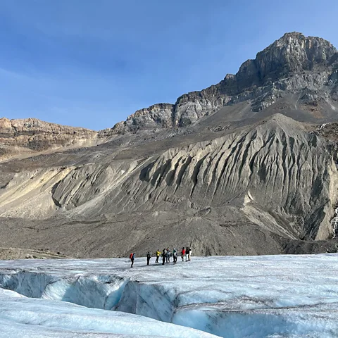
"These markers show just how much the glacier has retreated in the last century, but they're more like tombstones," said Tim Patterson, the owner of Zuc'min Guiding, which offers Indigenous-led excursions across Alberta and British Columbia with its team of Secwépemc, Métis and Siksikáí'tsitapi guides. In the 1970s, Patterson and I would have been standing atop 200m of ice at the Athabasca Glacier. But as the markers revealed, the glacier has steadily receded since 1890, leaving a desolate moonscape of gravel in its wake.
Today, the Athabasca is North America's most-visited glacier and one of the world's most gut-wrenching vanishing acts. As climate change accelerates, this 10,000-year-old ice sheet is now retreating 9m annually and is expected to disappear by 2100. More than 1.2 million people come to see it every year – many on shuttle buses that plough across the fragile landscape. Since 2022, Patterson, who is Nlaka’pamux, has been offering low-impact Indigenous-led hikes across the glacier, and after handing me a pair of crampons, he began recounting the area's significance to First Nations communities.
"Many groups have creation stories about the glaciers. It was the main source of water, so everything kind of comes from it," Patterson said, dipping his water bottle into a stream tumbling down the moraine. "Families would use these passes to hunt mountain goat and caribou, and harvest medicinal herbs."
One such family was Lauren Moberly's, whom I met the following day in Jasper National Park. A member of the Aseniwuche Winewak Nation, Moberly explained that her ancestors guided early explorers through the mountain passes lining the Parkway for generations before they were evicted in 1909. Since 2023, she's been leading helicopter tours above Jasper, whisking travellers across much of the now-scorched land to reveal the Miette Hot Springs her great-great-grandfather discovered, her family's still-standing homestead and the 200km path they were forced to trek out of the park.
 Eliot Stein
"These stories were erased for so long and needed to be heard," she said. "It's a completely different narrative now. We're finally taking steps to reclaim our place here."
While pointing out an encyclopaedia of edible plants to me near the Athabasca River two days later, Matricia Bauer explained why she believes Indigenous tourism has grown sharply since 2021 across the nation. "There's a lot more emphasis on Truth and Reconciliation in Canada now," said Bauer, a Cree guide who runs Warrior Women, which offers First Nations-led hikes and cultural experiences in Jasper. "For so long, Indigenous stories have been appropriated and misappropriated, and now people are trying to understand the real history of what happened here."
More like this:
• Kayaking the waters that shaped New York City
• The Indigenous tribes reclaiming travel
• Paddling the dramatic 'Grand Canyon' of Canada
In recent years, Wesley has been working with officials in Jasper to share that history. Today, travellers on the Spirit Island boat cruise receive a greeting in the Stoney language, learn the island's original name and hear about the hunter who revealed it to the outside world. They also learn why the Stoney have returned to the island to perform healing ceremonies every year since a wildfire burned the Maligne Valley in 2015 – a ritual that felt especially pressing in 2025 following Jasper's once-in-a-century blaze that somehow spared Maligne Lake.
 Eliot Stein
"If people go to one area too many times, they're going to exhaust that area. It's not sustainable," Wesley told me. "Now that the world knows about Spirit Island, we need their help to let us maintain it."
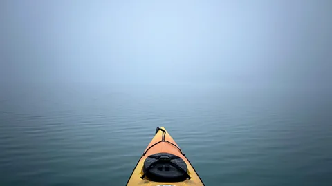
Paddling to Spirit Island
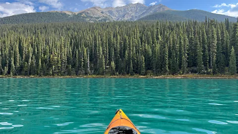
After braking for more than a dozen moose and watching bald eagles swoop over the mirror-like surface of Medicine Lake on the hour-long drive from Jasper to Maligne Lake, I pushed off into its crystal-clear waters and peered down to watch rainbow trout darting below my kayak.
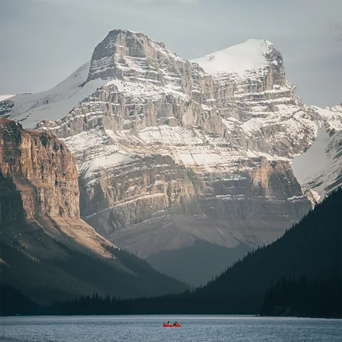
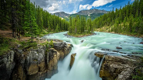
In front of me, a wall of evergreen trees lining the banks reached up from the azure water towards the jagged shale crags and snow-dusted peaks. As the Mary Schäffer Loop vanished behind me, I wondered whether she would have recognised this scene. But as I continued south towards the glaciers and two summits that the American explorer named after her Stoney guide and his wife – Samson Peak and Leah Peak – the scene abruptly changed: the light-blue water was now an intense turquoise.
Paddling to Spirit Island isn't just a soul-stirring experience; it's a kaleidoscopic one as well. When ice from the surrounding glaciers melts and flows into the lake, it releases finely ground "rock flour" that can appear milky blue, mesmerisingly green or anywhere in between in the sunlight. The closer you travel to the island and glaciers, the more intense the colour becomes.
 Eliot Stein
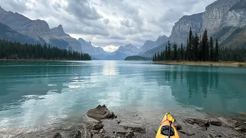
Three hours and 13km after setting out, the mountain walls closed in tightly at the aptly named Samson Narrows before opening up to reveal a jaw-dropping view of the Hall of the Gods in the distance. I paddled slowly, taking it in before tucking into a small inlet on the left to find my home for the night: the Fisherman's Bay campground.
After pitching my tent to face the Mt Unwin glacier and stringing a hammock between two pine trees, I followed a billowing trail of smoke to the communal firepit to meet my fellow campers. Of the group's six other paddlers, three had arrived in kayaks, two in canoes and one – a Lithuanian man who had never kayaked before – courtesy of rescue boat.
"People need to understand what they're getting into out here," said Heidi Fengler, a Parks Canada resource conservation technician who had scooped up the man after he'd flagged down a passing tourist boat heading towards Spirit Island. "This isn't a place for novices. The water is about 4C, and if you flip over, you might not make it to the shore."
The other paddlers had fared much better, and as we sat around the crackling fire, I asked them what had lured them here. Two were Air Canada flight attendants who told me they had been planning this trip for two years. One was a woman from Taiwan, who said she had dreamed of seeing Spirit Island ever since she saw an image of it years ago. Another was a retired Outward Bound guide, who echoed Schäffer Warren's famous quote: "Lake Louise is a pearl; Maligne Lake is an entire pearl necklace."
 Eliot Stein
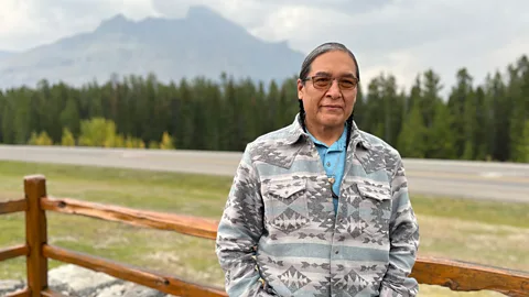
Then there was Jake Graham, a professional landscape photographer who said he's paddled out here 15 to 20 times in the last few years to shoot Spirit Island. "I've photographed in 12 of the 13 Canadian provinces and territories, and this is one of the few places I'll never get sick of," he said.
As the afternoon sun dipped behind the Queen Elizabeth Range, I lowered myself back into my kayak to see Spirit Island for myself. Pushing out of the inlet, I rode a rollercoaster of waves from the near-constant cruise boat traffic, and after rounding a cove, the island burst into view, stopping me mid-stroke in sheer awe.
I drifted cautiously towards its rocky shore, keeping a safe distance in the water and only coming close enough to spot a sacred Stoney staff planted upright like a totem that Wesley had asked me to look for. He explained that after the Stoney perform their healing ceremonies and introduce themselves to the new growth each spring, they leave a staff as a sign of gratitude to the land. In recent years, Wesley said that some travellers had trespassed onto Spirit Island and stolen their staffs, and he wanted to make sure it was still there.
At the water's edge, a sign tacked to a tree stump now reads: "Spiritual and fragile area. No access."
 Jake Graham
I beached my kayak by the boat dock facing the island and followed the long line of cruise boat passengers up a short trail towards a viewing platform overlooking the famous scene. I stood there spellbound for two hours, watching the scene shift as light danced across the peaks, shadows ran up the ridges, and clouds chased away the island's backlit glow. At one point, a woman with a British lilt noticed the paddle by my side and said, "You're lucky. We've got to race back on the boat."
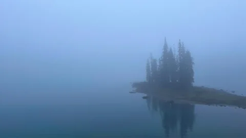
In fact, the one constant was the persistent rumbling of cruise boats, the steady stream of day-trippers jostling for space and the blaring foghorn calls telling them all to head back to the dock when their 15 minutes were up. I had planned to stay long after the last cruise ship left at 18:00 to soak in Spirit Island's serenity, but as the sky suddenly darkened and the heavens above the Hall of the Gods opened, I retreated back to the campsite. Lying awake in my tent that night and looking up at the Milky Way splashed across the world's second-largest dark sky preserve, I decided to return to Spirit Island at dawn to listen, just as Wesley had recommended.
What should have been a straightforward 1km paddle from Fisherman's Bay quickly became a 45-minute quest through an impenetrable fog bank. When Spirit Island's faint contours finally appeared, Graham was already there, clicking away in the mist. We greeted each other in hushed tones and had the whole place to ourselves. "Nine times out of 10, no one is here at this time," he said quietly.
 Eliot Stein
I sat silently on a rock under the viewing platform, gazing out towards the island and running my feet over littered cigarette butts on the ground – tiny reminders of a world increasingly on fire. Cloaked in a cloud and surrounded by a vast, indiscernible nothingness, the sacred island stood all alone amid the uncertainty around it.
As I searched through the mist for the Stoney's staff on their small, sealed-off island, I was reminded of something Wesley told me: "My ancestors wanted to protect this place because they saw something in the future that others couldn't. We still do today."
Eliot SteinCustodians of Wonder: Ancient Customs, Profound Traditions, and the Last People Keeping Them Alive.
--